“Whiteout Solutions provided comprehensive data and mapping that clearly delineated potential trail paths through the Lancaster Town Forest that would avoid sensitive areas while taking advantage of views and other aesthetic details. Their technology-based approach collected much more data than the Town otherwise could have gathered and saved countless hours of personnel time. Beyond trail planning, Whiteout Solutions’ work will provide the town with baseline data sets to use in managing invasive species and protecting wetlands into the future”
Across northern New England and New York, the Northern Forest Center helps rural communities leverage their best assets to improve the local economy and revitalize their towns. The work the Center does ranges from supporting entrepreneurship and innovation in the forestry industry to building housing and improving outdoor recreation assets. In Lancaster, New Hampshire, the Center is helping establish a series of walking, biking, and general use trails. One of the potential areas for development is the dense 283-acre Town Forest. Before establishing any new trails, the Center and the Lancaster Conservation Commission wanted to better understand the unique ecological features of the forest and the suitability of the terrain for the proposed trails. As a geospatial technology company with extensive work in forestry, Whiteout Solutions was well suited to support this project on both the data collection and analysis side.
Objective: The objective of this project was to establish a baseline dataset for planning trailhead accessibility, recreation trail development and conservation planning. LiDAR and multispectral imagery would be collected from a UAV. The project was to be conducted in June during leaf out or fully vegetated condition, this required flights to be conducted at slower speeds for LiDAR to ensure penetration of the tree canopies. Digital terrain models (DTM) from LiDAR data would provide a foundation to conduct a suitability analysis that highlighted the best location for trail development and accessibility. The criteria for the analysis weighted a series of factors including slope of terrain, water runoff, proximity to parking, proximity to old logging roads and trail standards like IMBA trail grading system. When pairing the DSM, DTM, multispectral imagery and available wetlands data, we were able to produce a map that delineates the most sensitive areas in the forest, unhealthy vegetation, and probable tree species – all insights that help with on-going conservation efforts.
Challenge: To date the Town Forest had been underutilized. The town recently conducted a timber sale, and a decade ago had created a hiking trail through the forest, which has since grown over. The only direct access to the forest was through an unmaintained road shared only by owners of a few camps. Easements had been established on the north side of the forest, but to-date no trail or parking had been established to allow access. Additionally, the forest is very dense, with an abundance of high and low vegetation. The terrain is rolling with some steeper areas and other swampy wetland zones. Both accessibility and the overgrown vegetation and terrain were key factors in the forest’s underutilization.
Effective planning for new trail development required a better understanding of all the factors above, which could be achieved by collecting high resolution imagery and LiDAR. Pre-planning the data collection missions are critical for all projects. For this project, we encountered large swaths of land with no available take-off or landing zones for our UAVs due to canopy density. The terrain varied greatly with rolling hills obstructing visibility of the collection areas, large ponds, and transmission power lines. All these factors meant that battery management and flight planning had to be done with precision to ensure data quality and safety.
This project included a variety of stakeholders, including the project leader from Northern Forest Center, the town manager, conservation committee members, consulting ecologist and trail builders. Each of these stakeholders had different levels of experience with geospatial data and hoped to get different answers from the data. We strongly believe that the value of LiDAR and other remote sensed data comes when it is combined to tell a more comprehensive story. The final deliverables for this project included ten different datasets and analyses. For deliverables to generate value over time for stakeholders, especially those who are not geospatial professionals, it’s our responsibility to create data and imagery that can be digested in a glance and each interaction expands the comprehension of the data. We found that providing the deliverables in an interactive website including descriptions of the datasets help reduce confusion and adds value to the data overtime.

Project Specs:
Client: Northern Forest Center
Collection Services: Aerial LiDAR, Multispectral and Orthomosaic
Processing and Analysis: Classified Point Cloud, Digital Terrain Model, Digital Surface Model, Elevation Contours, High resolution Orthomosaics, Broad range indices generation, Tree Segmentation, Tree species classification, Wetlands Analysis, Slope Analysis, Trail Suitability Analysis, Invasive Species Analysis

Trail Suitability Analysis – The development of a suitability analysis is a inherently a collaborative process, as we work directly with stakeholder to outline criteria and establish a weighting systems appropriate for the datas final application. In the Lancaster Town Forest we took into account eight criteria including trail and natural land features, slope, aspect, proximity to wetlands, soils data, existing trails, proximity to parking and emergency exits, IMBA and ADA criteria. The final result of the analysis is a raster dataset with a color ramp applied highlights areas best suited for trails. Based on the suitability outputs, we proposed a series of trails which Northern Forest Center will utilizes in their planning efforts.

Tree Species Detection – In order to conduct a tree species analysis, Whiteout Solutions utilizes two sets of data, the first is a high density point cloud(200+ ppsm) and multispectral imagery. We run the LiDAR point cloud through our proprietary tree segmentation analysis tools to isolate individual trees and assign them a unique ID. From there we generate polygons from each tree and run a machine learning process on the multispectral imagery to determine the species of tree isolated in each polygon.
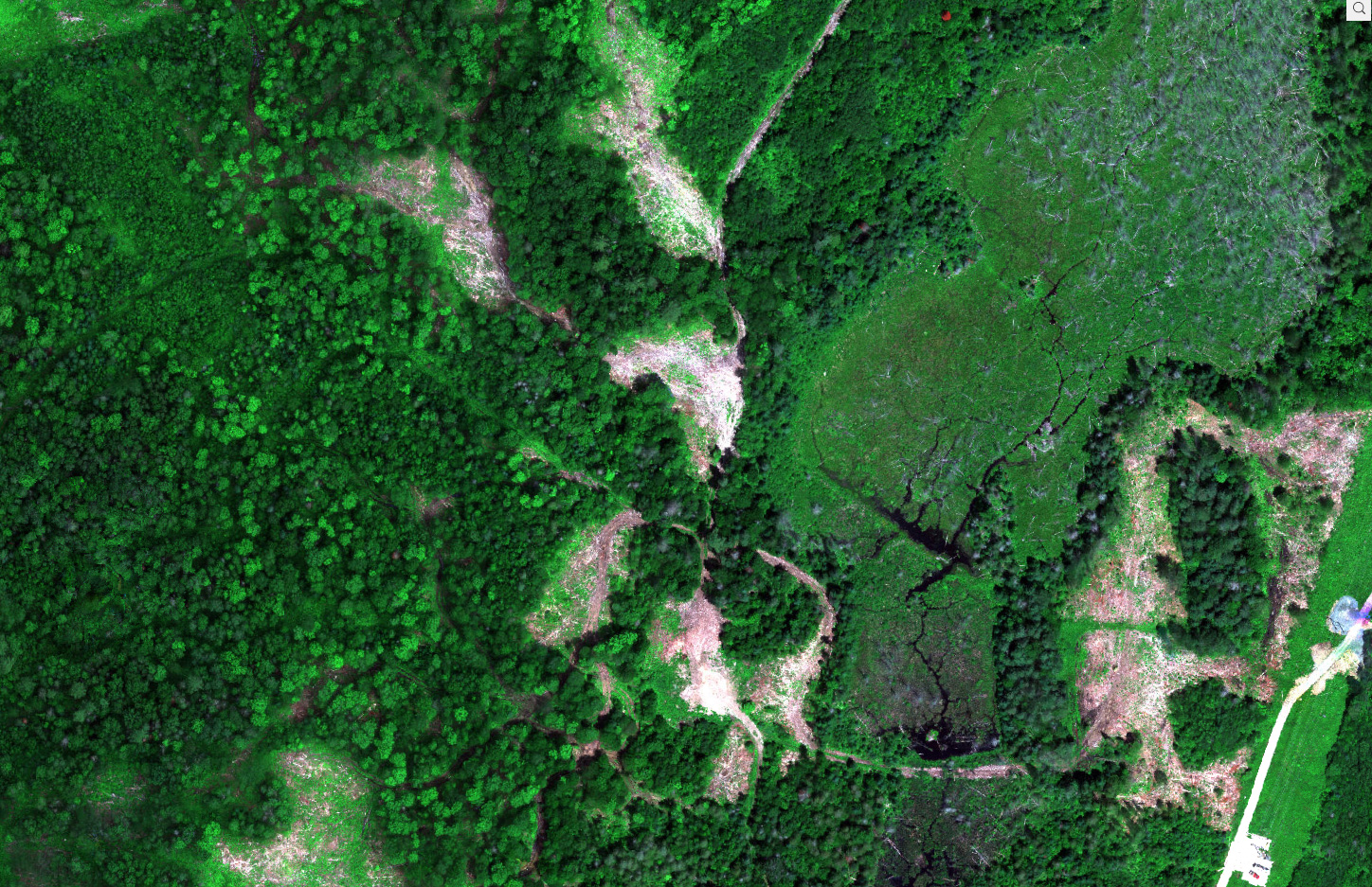
Wetlands & Logged Areas of Lancaster Town Forest
Showcase of various ecologies in the Lancaster Town Forest
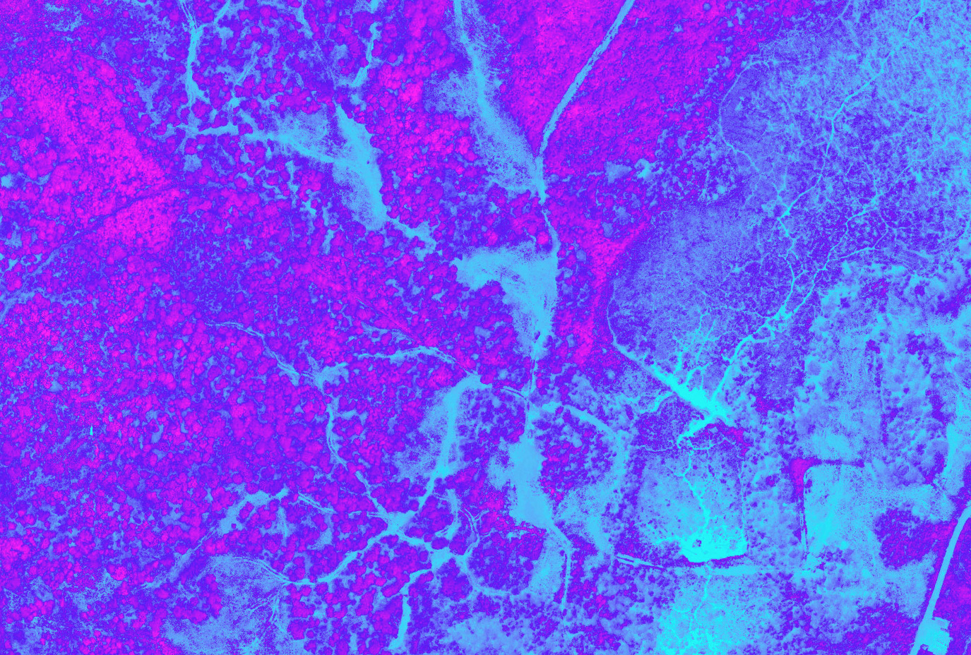
RTVI Core Biomass Imagery of the Lancaster Town Forest
RVTI Core highlights concentration of biomass with a color ramp. Pink is the highest volume of biomass, blue is the lowest.

Lancaster Town Forest Orthomosaic Image
Image highlighting the density of the town forest canopy


Solution: UAV Mounted LiDAR was utilized to collect the Town Forest area as it was able to penetrate the dense canopy to survey the ground surface. A fixed wing UAV was utilized to capture multispectral and orthomosaic imagery. LiDAR, multispectral and orthomosaic processing was utilized to derive outputs required for suitability analysis and other forestry analytics. Those processes output the following:
- Classified Point Cloud
- Digital Terrain Models & Digital Surface Models
- Elevation Contours
- High resolution orthomosaics
- Broad range indices generation
- Tree Segmentation
- Tree species classification
- Wetlands Analysis
- Slope Analysis
- Trail Suitability Analysis
- Invasive Species Analysis
Results:
- Produced an expansive dataset that provided clear guidance for the Northern Forest Center and other stakeholders on where trails should be built based on criteria they had established.
- Pre-existing trails, wetlands, and other important features we detected and clearly delineated in dataset.
- Additional forestry analysis was conducted, segmenting roughly 57,632 trees and their species.
- Deliverables were published to an interactive web experience allowing less technical users to explore and interrogate the data.