A Geospatial
Technology Company
Automating data acquisition, post-processing and data delivery
to help organizations make better decisions
End-To-End Solutions
for Geospatial Data
Whether it’s the delivery and sharing of large scale geospatial datasets in geoSAP, workflow automation for complex environmental analysis, or data acquisition using our suite of aerial systems, Whiteout Solutions has the dedicated resources to support your needs. Our team has extensive experience working with LiDAR, Imagery, vector, raster and many other geospatial data types to provide mission critical information to our partners. Our experience is vast and includes work in coastal and water resource management, utilities and telecom, forestry, insurance, outdoor recreation and more.


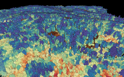
Providing high resolution Topobathy LiDAR
Explore the depths with Whiteout Solutions’ topobathymetric LiDAR service, offering unparalleled topographic and hydrographic data and analysis. Fueled by innovations in UAS, we targeted surveys for coastlines, rivers, lakes and critical infrastructure like dams, bridges, and shipping channels. Trust us to provide accurate high resolution data in a timely manner.

Solving geospatial big data problem.
Access your geospatial data anywhere through geoSAP Field, Fusion, & Cloud. Large 3D LiDAR point clouds, multi-gigabyte orthomosaic images, one hundred million vertice vector shape files; geoSAP can deliver it all. geoSAP leverages modern data structures and cloud storage to delivery geospatial data on the web or on-premise, making it accessible and visual to anyone, anywhere.


Aerial & Terristrial Data Collection
Data collection services include LiDAR, Topobathymetric LiDAR, Hyperspectral, HD RGB and other photogrammetric, remote sensing and orthomosiac captures. We can capture data using helicopter, vehicle mounts or geostationary devices.

Data Processing
Geospatial data is only as valuable as the insights that are derived from it. Our refined processing methodologies through geoSAP Fusion (one of our many solutions), allows us to process the highest quality data with extreme accuracy and efficency.

Automated WorkFlows with GeoSAP
GeoSAP makes workflow automation easy for anyone in an organization. With GeoSAP, teams can quickly process complex geospatial datasets and get actionable insights in a presentable format.

Continuous Collection Services
The power of data grows exponentially when an organization can layer historical datasets to understand how environments change. Whether it’s measuring changes to road surfaces or vegetation changes due to climate change, continuous collection gives real-time datasets for critical and time sensitive analysis.

Products
We offer a variety of products to support complex geospatial data, from automation applications and managed geodatabases to development and integration of continuous collection systems.

Consulting Services
Our team of engineers, GIS analysts, FAA certified UAV pilots and product development professionals have deep experience and are available to help your organization with any geospatial data challenges that arise.
Markets
We have deep experience across a range of industries, giving us a perspective on the types of deliverables each requires.

Maritime & Coastal
Tranportation
State & Local
Defense

Engineering

Infrastructure

Agriculture
Education

Environmental

Government

Foresty
Science & Technology
Our Work
Our Clients and Partners do transformational work to make our world a better place. The work we produce for them helps them achieve their goals, adding accuracy and efficiency to their projects.
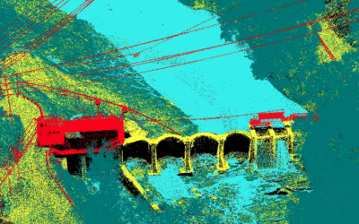
Topobathy LiDAR for Dam Removal Monitoring on Oconaluftee River
The Ela Dam on the Oconaluftee River...
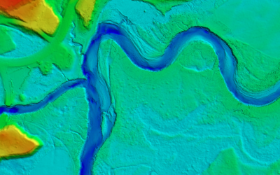
Riverine & Floodplain Mapping with UAS Topobathymetric LiDAR
The Town of Lyndon, Vermont, is...