Newsroom
Explore groundbreaking geospatial technology and innovations that redefine mapping solutions.
Cutting-Edge Mapping
Innovative LiDAR Solutions
Industry Leaders in Geospatial Tech


Articles & Blog
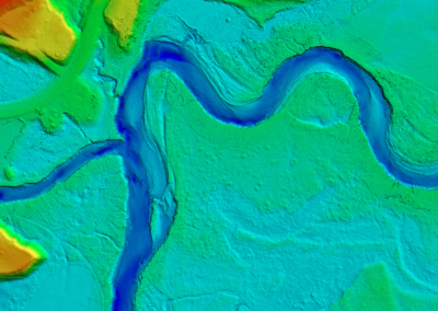
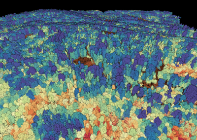
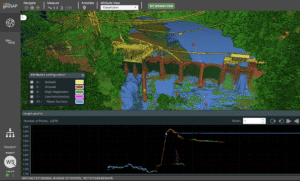
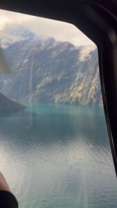
Beneath the Surface: Mapping the San Joaquin River in 3D
Published 06.01.26
Rivers are constantly changing. Water levels rise and fall, sediment shifts, banks erode, and infrastructure must adapt to an environment that is always in motion. Understanding these changes requires more than a traditional survey; it requires a complete picture of both the landscape above the water and the channel hidden below it.
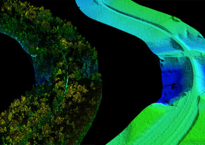
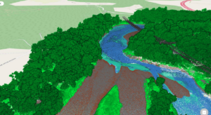
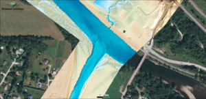
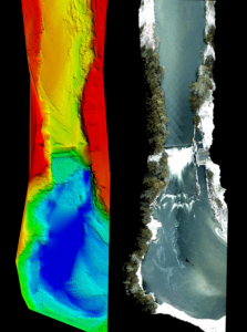
To support that effort, Whiteout Solutions recently completed the integration of topobathymetric LiDAR and multibeam sonar data for the San Joaquin River near Stockton, California.
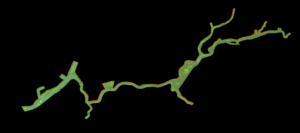
The project combined twocomplementary technologies to create a seamless, high-resolution elevation model across the land-water interface. Topobathymetric LiDAR captured floodplains, riverbanks, levees, and shallow-water environments, while multibeam sonar mapped deeper portions of the river channel where LiDAR penetration becomes limited.
The result is a continuous digital representation of the river corridor—from the tops of the banks to the deepest sections of the channel—providing engineers, planners, and environmental professionals with a more complete understanding of the system.
Integrated datasets like these play a critical role in flood modeling, infrastructure assessment, sediment transport analysis, and environmental restoration planning. By eliminating gaps between terrestrial and underwater data, decision-makers can better understand how water moves through the landscape and how river systems evolve over time.
As demand grows for more accurate environmental intelligence, projects like this demonstrate the value of combining advanced geospatial technologies to reveal what cannot be seen from the surface alone.
Project Location: San Joaquin River, Stockton, California
Technologies: Topobathymetric LiDAR & Multibeam Sonar
Applications: Flood Modeling, Infrastructure Planning, Sediment Analysis, Environmental Restoration
Click on the video below to view a sneak peak into our incredible product.
Small Sensors, Big Results: Whiteout Solutions' Trevor Hobbs Showcases Topo-Bathymetric LiDAR at CHC 2026
Published 06.08.26
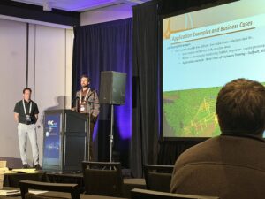
MONTREAL — April 2026 — At the Canadian Hydrographic Conference 2026 in Montreal, Trevor Hobbs, Senior Geospatial Analyst & Geomorphologist at Whiteout Solutions, delivered acompelling presentation on the implementation and processing of data collected by compact, next-generation topo-bathymetric LiDAR sensors. The presentation showcased how these systems are transforming the way surveyors map the complex interface between terrestrial andaquatic environments.
Hobbs presented alongside Michael Sitar, Managing Director of RIEGL Canada, in a joint session titled, “Small Sensors, Big Results”; both of which drew on Whiteout Solutions’ growing portfolio of real-world field deployments.
At the heart of their presentation was what Hobbs described as a fundamental data gap problem. Traditional near-infrared (NIR) LiDAR systems are blind to water. They cannot penetrate the surface to capture riverbeds, nearshore bathymetry, or the shallow zones critical for flood modeling and coastal management. Green-wavelength (532 nm) topo-bathymetric LiDAR fills that gap, penetrating clear to moderately turbid water to map riverbeds, estuaries, and shallow coastal zones in a single pass.
The challenge, historically, has been size and cost. Until recently, systems capable of this kind of survey required large, expensive aircraft and substantial logistical footprints. RIEGL’s latest sensor portfolio and Whiteout Solutions’ operational experience deploying it is changing that calculus.
Institutional Involvement
Both presenters placed their technical work in the blatent demand for topo-bathymetric products. Canada’s National Elevation Data Strategy, coordinated through Natural Resources Canada, calls for seamless, high-resolution 3D mapping of land and shallow waterbeds, with particular emphasis on flood hazard mapping, high-risk coastal zones, and improved shoreline representation through a land-water continuum approach.
South of the border Canadian border, the USGS 3D Hydrography Program (3DHP) (the hydrography component of the broader 3D National Topography Model initiative) is driving federal priority acquisitions across the United States, with high-priority collection zones concentrated in mountainous regions and inland riverine corridors where terrain variability and sensor altitude constraints make collection particularly challenging.
These government mandates represent a significant and growing market for topo-bathymetric data collection, and that the new generation of smaller sensors paired with Whiteout’s operations and processing are well positioned to serve the dispersed, complex, and often remote areas these programs prioritize.
In the Field: Two Deployments, Two Platforms
The core of Hobbs’ presentation is rooted in three Whiteout case studies:
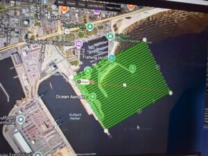
Gulfport, Mississippi: UAV Training with the Army Corps
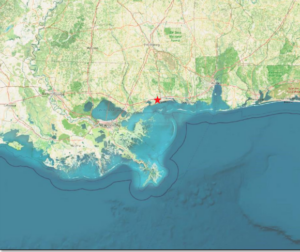
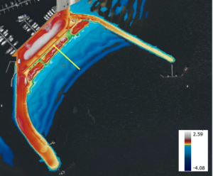
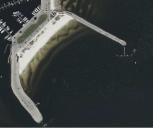
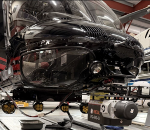
Working alongside the U.S. Army Corps of Engineers and NAVOCEANO, Whiteout Solutions evaluated the RIEGL VUX-820-G in a turbid deltaic coastal environment near Gulfport, MS. The mission served dual purposes: assessing sensor performance in challenging, low-clarity Gulf Coast waters and providing hands-on training to Army Corps personnel in UAV data acquisition and processing using RiPROCESS and RILOC.
The resulting point cloud data clearly resolved the land-water interface distinguishing ground, low vegetation, water surface, and bathymetric bottom returns. This remains true even in conditions where turbidity significantly limits optical penetration. The depth range captured spannedfrom approximately +2.59 m above water to -4.08 m below the surface.
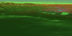
Winooski River, Richmond, Vermont: Flood Mitigation from the Air
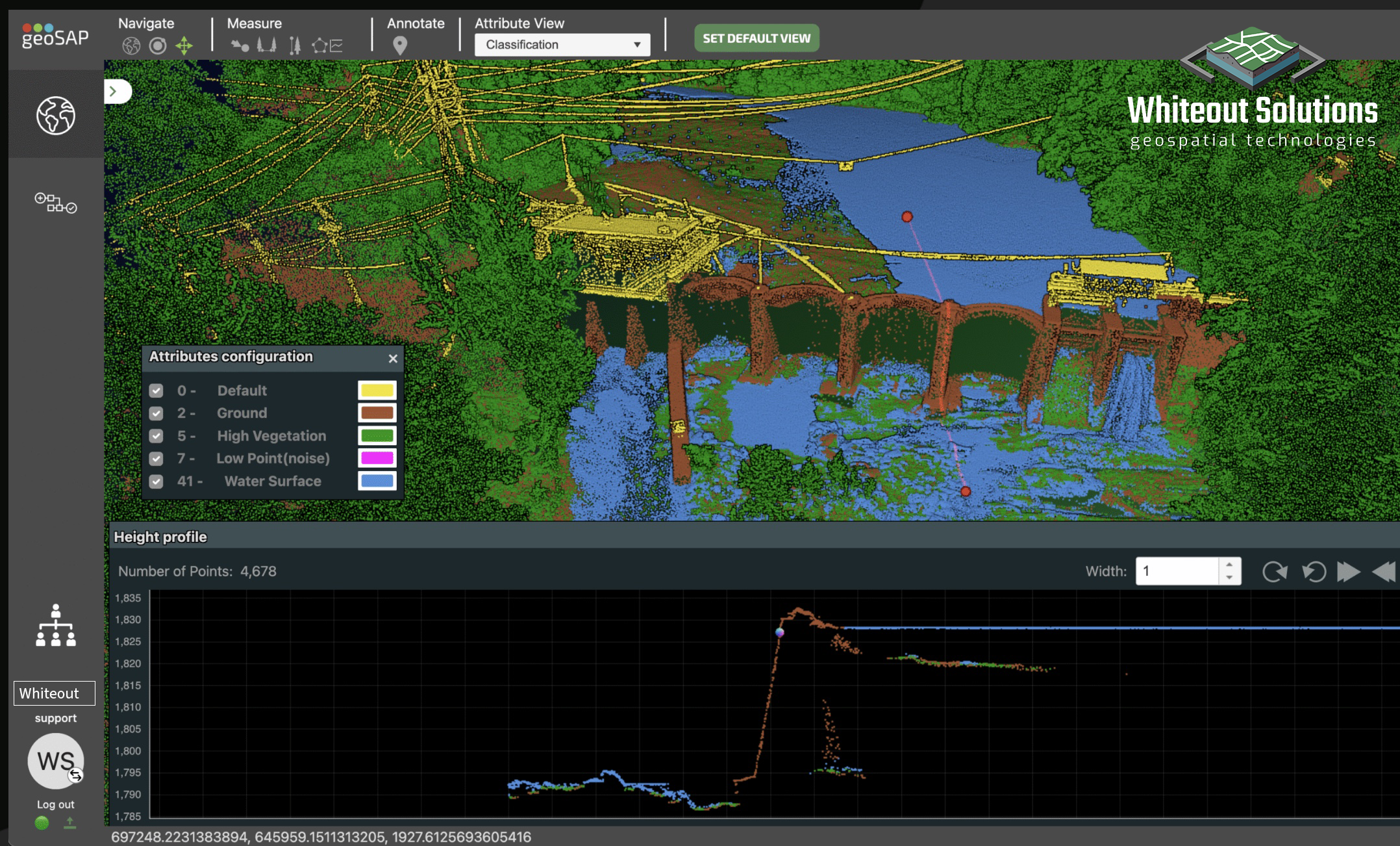
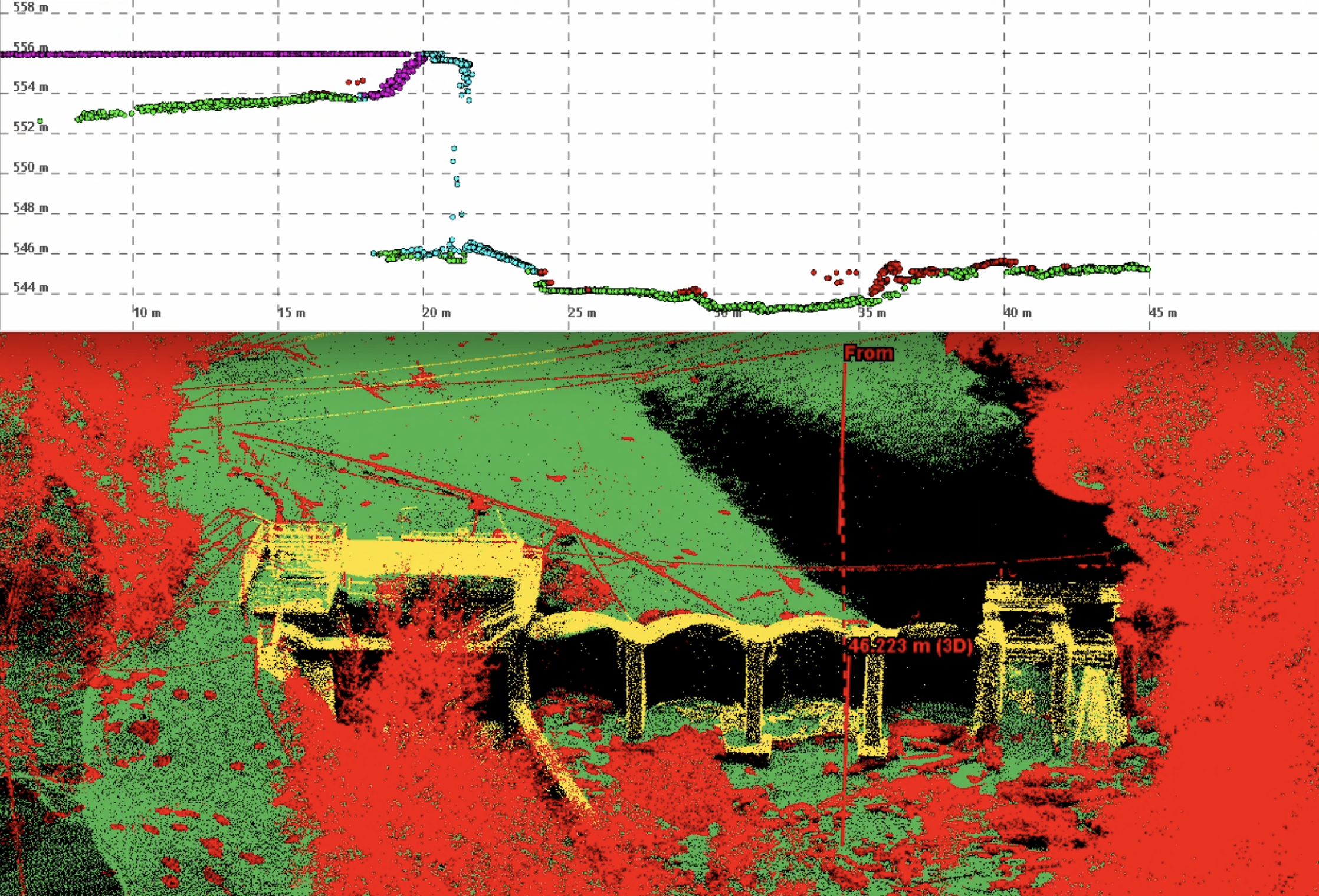
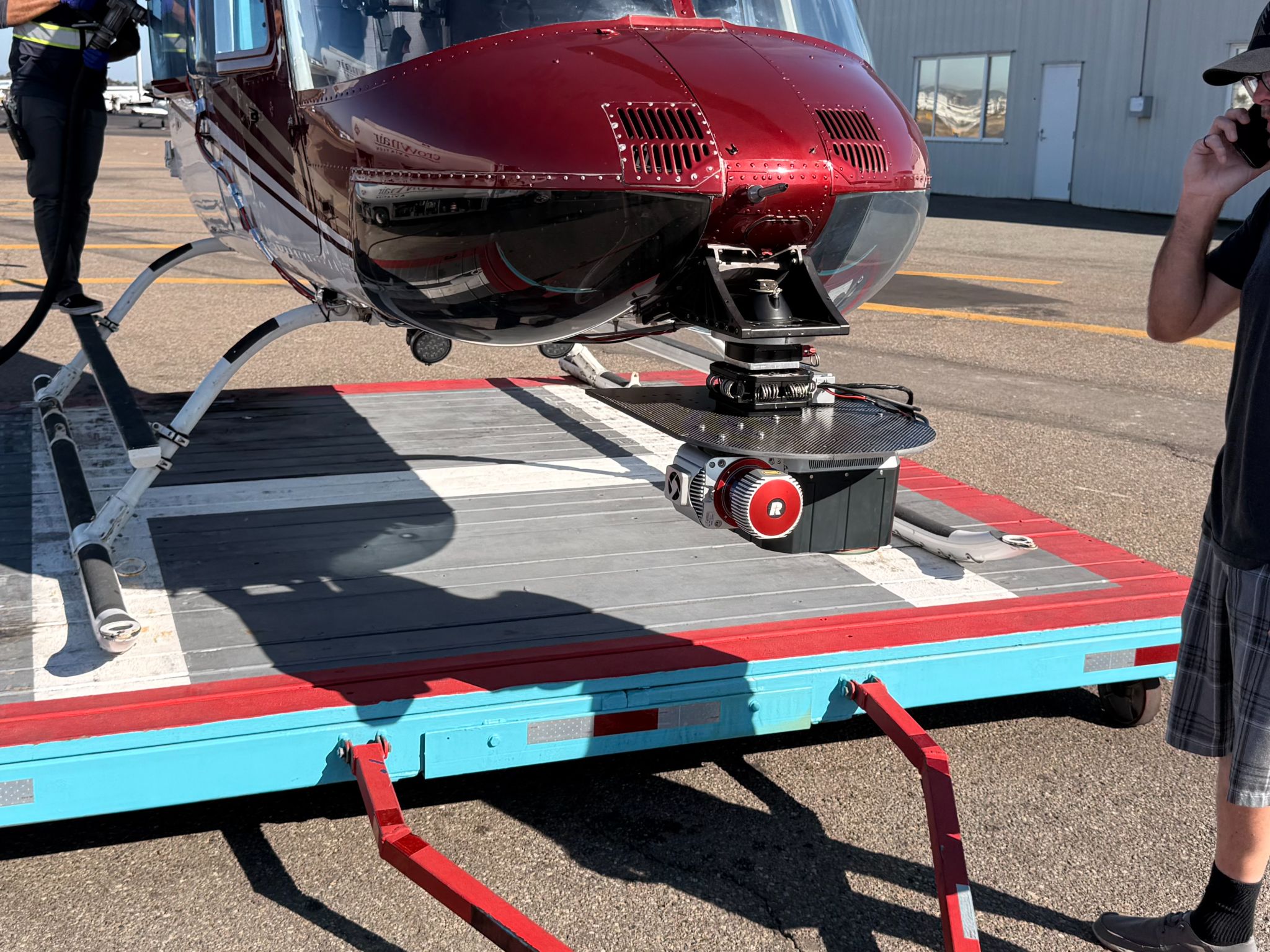
Vermont’s Winooski River corridor near Richmond has seen repeated and damaging flooding in recent years, affecting wastewater infrastructure and residential properties. Whiteout Solutions deployed the RIEGL VQ-840-GL aboard a Bell 206 helicopter to develop a high-resolution topo-bathymetric elevation model in support of hydrologic modeling and flood mitigation planning for the town.
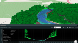
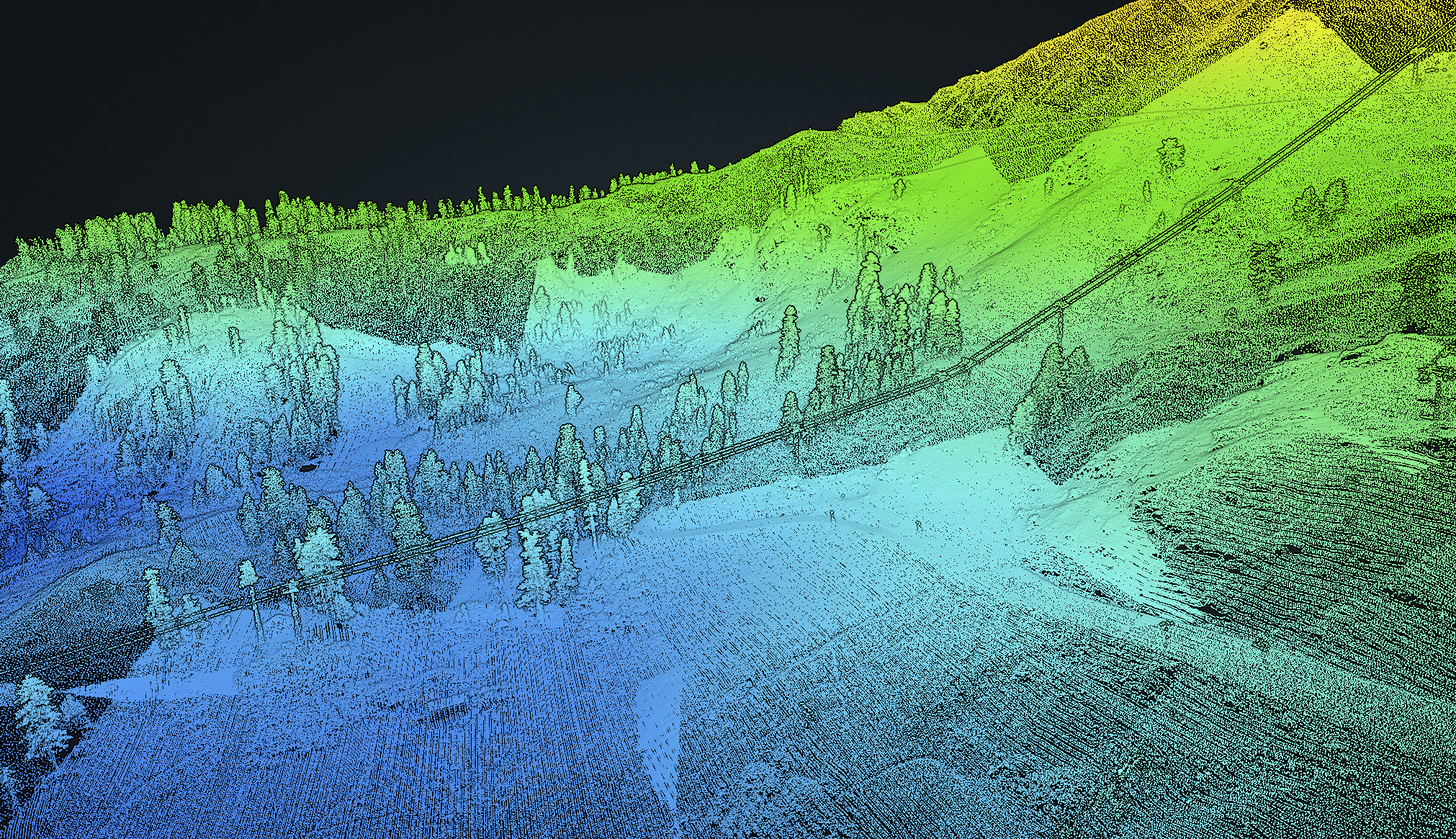
The resulting data product was striking in its resolution and continuity — seamlessly mapping the riverbed, water surface, adjacent floodplain, and riparian vegetation in a single dataset. Height profile analysis of the point cloud revealed the river cross-section in fine detail, with 72,941 points captured in a single swath slice, clearly showing the transition from upland forest through riverbank to the submerged channel bottom.
Processing the raw waveform data using Exponential Decomposition (XDC) yielded dense, well-separated returns for the bathymetric bottom, water surface, and coastal marsh zones; though Hobbs noted that the technique also introduced a significant volume of low-noise points requiring careful filtering.
Broader Applications: Coastal Marsh and Turbid Rivers
Hobbs expanded the picture further with two additional case studies.
For the Connecticut DEEP Coastal Marsh Mapping Project, Whiteout Solutions tackled one of the more logistically demanding topo-bathymetric assignments imaginable: 300 discrete areas of interest totaling approximately 14,000 acres and stretching across roughly 155 km of complex, estuarine Connecticut coastline. The team deployed an integrated payload combining the RIEGL VQ-840-GL (green, topo-bathy), RIEGL VUX-1LR (NIR, topographic), and a SPECIM multispectral sensor for vegetation mapping.
Physical access to the marsh environment precluded traditional ground control placement. Whiteout’s solution was to harvest synthetic ground control points from USGS 3DEP LiDAR data, using a stratified random scheme scaled by AOI size. Independent high-accuracy control collected at accessible locations (80 points project-wide) confirmed overall accuracy, with swath-to-swath elevation differences clustering tightly around a mean of +0.030 m.
Geospatial technology, while seemingly a niche industry, continues to be integral to understanding and solving some of the world’s most complex challenges on the earth’s surface. Whiteout Solutions is proud to be at the forefront of that effort, developing innovative geospatial technologies that help transform complex data into actionable solutions for our clients. We are additionally incredibly proud of our team of analysts, in field operators, and everyone in between that helps bring each product to fruition.
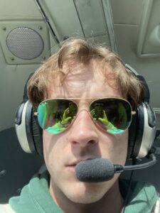
A Conversation with Whiteout's Sensor Operator, Brayden Sellers
Published on: 06.03.26
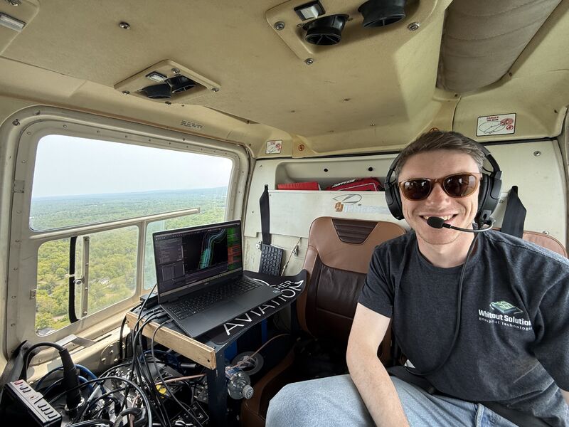
At Whiteout Solutions, collecting high-quality geospatial data starts long before a project reaches the processing stage. Behind every LiDAR point cloud, elevation model, and bathymetric dataset is a team working in the field to ensure the data is collected accurately, efficiently, and safely.
One of the newest members of that team is Brayden Sellers, Whiteout’s Sensor Operator. Brayden brings a unique perspective to the role, having worked on both sides of the geospatial workflow; from processing data in the office to collecting it from aircraft in the field.
“I started out with a GIS background,” Brayden explains. “I spent a lot of time doing LiDAR classification, point cloud cleaning, imagery quality control, and working with shapefiles and raster data. Having that experience helped me understand what good data looks like before I ever started collecting it.”
That experience has become a major advantage in airborne acquisition. Because he understands the challenges faced by processing teams, Brayden can identify potential issues while data is being collected rather than after the aircraft has landed.
“If I knew the office wouldn’t like receiving a certain dataset, I could make adjustments during collection,” he says. “It helps bridge the gap between acquisition and processing.”
What Does a Sensor Operator Actually Do?
A typical project day starts well before takeoff. Weather forecasts are reviewed. Flight plans are confirmed. Airspace restrictions are checked. Communication with pilots begins early to ensure everyone understands the mission objectives and any challenges that may arise.
“There are a lot of things that have to happen before you even get off the ground,” Brayden says. “The pilot needs the flight plans, permissions need to be in place, and we need to make sure weather conditions are suitable for collection.”
One of the challenges of airborne LiDAR operations is translating technical collection requirements into practical flight instructions. While pilots focus on safely operating the aircraft, sensor operators focus on data quality and coverage.
“Sometimes what I need to see as the sensor operator isn’t the same information the pilot is looking at,” Brayden explains. “Having tools that help communicate that information in real time is incredibly valuable.”
At Whiteout, this collaboration between pilots and sensor operators helps ensure projects are collected efficiently while maintaining the high standards required for precision geospatial analysis.
Brayden Explains Topobathymetric LiDAR with a Laser Pointer
One of the most common questions Whiteout receives is: What exactly is topobathymetric LiDAR?
Imagine shining a laser pointer at a mirror. If you had an incredibly precise stopwatch, you could measure how long it takes for the light to travel to the mirror and back. “Now imagine doing that millions of times every second while moving the laser across the landscape.”
“That’s basically what LiDAR is doing,” Brayden says.
By measuring the travel time of laser pulses, LiDAR systems calculate distances and create detailed three-dimensional models of the Earth’s surface.
Topobathymetric LiDAR adds another layer of capability. Unlike traditional LiDAR systems, specialized green-wavelength lasers can penetrate water. This allows the system to measure both the water surface and the riverbed, lake bottom, or coastal terrain beneath it. The result is a seamless dataset that captures both the terrestrial landscape and submerged environments. For projects involving rivers, shorelines, floodplains, and coastal environments, this technology provides critical information that would otherwise be difficult or impossible to collect efficiently.
The Growing Role of LiDAR in Geospatial Technology
Although LiDAR has become a foundational technology across the geospatial industry, Brayden notes that many GIS programs still devote surprisingly little time to it.
“I was surprised when I got into the industry and realized how much of modern geospatial work revolves around point clouds and three-dimensional models,” he says. “In school we focused heavily on maps, vectors, and rasters, but LiDAR wasn’t discussed nearly as much.”
As organizations increasingly rely on high-resolution elevation data for infrastructure management, environmental monitoring, flood modeling, forestry, and asset inventories, the demand for LiDAR expertise continues to grow.
The Human Side of Point Clouds
While most people think of LiDAR data as highly technical, Brayden says some of the most memorable moments come from unexpected details hidden within the data.
“My favorite thing is seeing people captured in crosswalks,” he says with a laugh. “The point cloud turns them into these little figures that look exactly like the walking person on a crosswalk sign.”
For those who spend enough time working with point clouds, the data begins to tell stories. Rivers reveal their depth. Highway rock cuts expose geological features. Entire landscapes emerge from millions—or billions—of individual points.
“It’s funny because after a while, things just start appearing,” Brayden says. “At first it’s just a bunch of dots. Then suddenly you can recognize roads, rivers, vegetation, and terrain almost instantly.”
Looking Ahead
As Whiteout continues expanding its airborne mapping capabilities across North America, Brayden will play a key role in collecting the high-resolution geospatial data that supports environmental analysis, infrastructure planning, hydrographic mapping, and remote sensing projects.
From coordinating with pilots to managing terabytes of data collected in a single day, the role of a sensor operator sits at the intersection of technology, aviation, and geospatial science.
And for Brayden, that’s exactly what makes it exciting.
“Every project is different,” he says. “You’re solving new problems, working in new environments, and helping create datasets that people will use to make important decisions.”
At Whiteout Solutions, those datasets begin with a laser pulse, a flight plan, and a dedicated team committed to collecting the best data possible.
Latest Announcements
Company News & Press
Whiteout Solutions Welcomes John Nett to the Team!
07.13.26
Whiteout Solutions is excited to welcome John Nett to the team, where he will help drive business development and expand the company’s growing presence across the geospatial industry.
John brings extensive experience at the intersection of technology, business development, and advanced geospatial solutions. Throughout his career, he has worked closely with government agencies, commercial organizations, and strategic partners to help solve complex operational challenges using software, remote sensing, and enterprise geospatial technologies.
In his role at Whiteout Solutions, John will focus on connecting organizations with innovative LiDAR, remote sensing, geoAI, and cloud-based geospatial solutions. Working alongside Whiteout’s technical and executive leadership, he will help clients leverage the full capabilities of the geoSAP platform and Whiteout’s advanced data acquisition and processing services to transform complex geospatial data into actionable intelligence.
As demand continues to grow for accurate, scalable geospatial solutions, John’s experience in building strategic partnerships and understanding customer needs will play an important role in helping organizations make better decisions with their data. His ability to bridge technical innovation with practical business outcomes aligns closely with Whiteout’s mission of delivering powerful, easy-to-use geospatial technologies that solve real-world problems.
“John understands that successful technology isn’t just about innovation—it’s about helping customers solve meaningful challenges,” said the Whiteout Solutions team. “His experience and relationship-focused approach make him an excellent addition as we continue to grow and expand the impact of our technology.”
Please join us in welcoming John to Whiteout Solutions. We look forward to the expertise, leadership, and industry perspective he brings as we continue developing next-generation geospatial solutions for clients around the world.
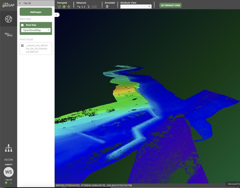
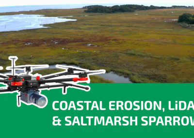
Whiteout Solutions Supports Lake Erie Shoreline Resilience Mapping for NYSDEC
06.15.26
Whiteout Solutions recently completed a topobathymetric LiDAR survey along approximately 65 miles of Lake Erie shoreline between Buffalo and Ripley, New York, in support of the New York State Department of Environmental Conservation’s Coastal Erosion Hazard Area (CEHA) mapping initiative.
The project captured both terrestrial and nearshore bathymetric data in a single integrated survey, providing a continuous, high-resolution representation of the coastal environment. The resulting dataset will help support updated erosion hazard mapping, coastal planning, infrastructure management, and long-term shoreline resilience efforts along one of New York’s most dynamic and erosion-prone coastlines.
Whiteout Solutions Completes Integrated Hydrographic Mapping Project in California
06.01.26
Whiteout Solutions recently completed the integration of topobathymetric LiDAR and multibeam sonar data for the San Joaquin River near Stockton, California. The project created a seamless elevation model across the land-water interface, capturing both terrestrial and underwater features throughout the river corridor.
The resulting dataset supports flood modeling, infrastructure planning, sediment transport analysis, and environmental restoration efforts by providing a comprehensive representation of river and floodplain conditions.
Whiteout Solutions Location Move Announcement
05.29.26
Whiteout Solutions is thrilled to announce the move to our new office in Derby, Vermont.
This strategic move will enhance our ability to serve clients across North America with greater efficiency and speed.
As Whiteout continues to expand, this space also allows us far more room for all of our equipment–including a state of the art facility for fabrication and engineering of geospatial technology.